Pages

Friday, February 29, 2008

Union Electric Power Plant

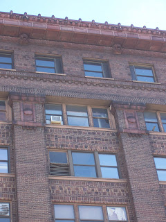
I love the details of the Union Electric power plant on the Landing in downtown St. Louis. From what I understand, it merely generates steam to heat downtown office buildings, but the residue from its coal-firing days still clings resolutely to it exterior. And what an exterior it is; the plant was built at a time when even utility buildings required a grand, elaborately detailed decorative scheme in the Beaux-Artes style.The building alternates tan brick for the exterior walls with stone decorative elements such as the giant Ionic pilasters on the front of the building.Even the roof looks more fitting for an English country house than for a power plant. The round window is transformed into a cartouche with elaborate filligry.I would love to be able to see the interior of this building; perhaps some of the ornate decoration of the exterior continues inside. Check out a bird's eye view here. If you look closely, you can see how a rail line once passed by the front of the building, causing a small triangular setback of the front facade.

Wednesday, February 27, 2008

St. Mary's Infirmary

While St. Mary's Infirmary has been heavily photographed and documented at other sites (and much more adeptly than me) I thought I would post a couple of pictures that I snapped while driving by one day.What is striking about this building is that it is hiding in plain view, so to speak. It sits right in the middle of a parking lot, and within throwing distance of Lafayette Square.Regardless, it should be restored, not just to stop the complete demolition of all historic structures south of I-64 and north of Chouteau, but because it would be a great adaptive reuse of an historic structure.Here is a bird's eye view of the old hospital. As it sits for now, devoid of development, one can only wonder what will become of it.

Tuesday, February 26, 2008

Old Open Air Shopping Malls

I am hoping that maybe someone out there can help me with something. I am searching for old photos of Northwest Plaza and Crestwood Mall before they were enclosed in the 1980's. Also, I would love pictures of any malls in St. Louis that depict their original interior decorations, which have gone the way of the dinosaur in so many local malls (remember those funky stainless steel sculptures at Chesterfield?).

I've discovered that there is better photographic documentation of the 1860's than the 1960's in published books and journals.

Thanks

New Mississippi Bridge Announcement

Well, as it turns out, they're going to build a new I-70 bridge across the Mississippi River north of downtown. The question that arises now is: how will it affect the Old North St. Louis neighborhood and the Near North Riverfront. And furthermore, how much of the plans on the official website are still accurate, considering the bridge has gone from 8 lanes to 4 (with 2 additional lanes for a later date)?

Through the use of published official plans and bird's eye satellite images, we can get a bit of an impression of how the bridge will affect the Missouri side of the construction. Let's first talk about the St. Louis approaches to the bridge east of I-70. As can be seen in this image, there really is not much in the way for a new bridge when you look at the land acquisition map; there's a couple of really deteriorated buildings that are in the way. I will say, I don't like how there will be a hulking interstate overpass looming over North Broadway; they have a nasty habit of killing pedestrian traffic. Admittedly, North Broadway at this location is largely industrial, but still.

What is more troubling is the street connection that heads out in a perpendicular fashion from the existing I-70 right of way and spills out onto Cass Ave; essentially people crossing the bridge who go straight will find themselves in the street grid of North Downtown. You can see an image here of the areas targeted for demolition for this portion here. I hate these street-to-interstate connections; having lived in Baltimore, I can tell you that streets surrounding such connections as planned for St. Louis are a disaster, crowded with hotheads trying to get onto the interstate while driving at interstate speeds. Here is what I'm talking about in Baltimore.

What does interest me is the possibility, however small, is that reasonable leaders might actually argue for the removal of the portion of I-70 south of the new bridge and north of the Poplar Street Bridge interchange. This section, which apparently would be added to a newly lengthened I-44, has long been a source of civic shame, cutting the Arch grounds off from downtown St. Louis. At the very least, the northbound ramp from westbound Poplar Street Bridge traffic should be removed, forcing I-70 traffic across the new bridge and cutting down on a major source of congestion on the old interstate bridge, seen here. Then they would just have to come up with a solution for the asinine exit for southbound I-55....

Monday, February 25, 2008

Benton Park

One of my favorite neighborhoods in the city is Benton Park, an area just west of I-55 from the more well known Soulard neighborhood. Benton Park is a beautiful part of town, and not really because it has dozens of mansions. Rather, it is a compilation of simple and elegant houses that work together to create some of the most intact and urban streetscapes in the city. Here is a bird's eye view of the neighborhood. Below is a typical house in the area, that is set back far from the street; I suspect that it was originally meant to be an alley house.Below are two great examples of houses that were clearly built at the same time, and show evidence that they are now being carefully restored simultaneously as well. I love Mansard roofs.Here is a house that is three stories tall next door; personally I think two story houses work better with Mansard roofs from a proportion standpoint.Below is a storefront that features apartments above; it would be perfect for a small, but classy, convenience store or coffee shop.The streetscape below illustrates well how each building is an integral part of a greater architectural "canvas." The four houses on the left appear to have been built speculatively at the same time. The rest are also very well preserved.This house, next to the four siblings, is a one-off design that looks well restored.Modern accoutrements, including a satellite dish, show how these 100 year old houses can still adapt to modern usage and habitation.Below is a type of rowhouse that is not very common in St. Louis: the three houses are essentially one big building that is made to look like three houses.I love the little one story rowhouses like the one below; the classical, Italianate cornice makes the little shotgun house distinct.Here is an apartment building or condo conversion, supplying the neighborhood with a variety of housing sizes and prices (though they are increasingly rising in the neighborhood).Below is an example of a more elaborate house sitting on the south side of Benton Park itself. The rounded windows, now nightmares for the modern restorer, were once very common in the houses of the middle class in the city.Even though I grew up in St. Louis, I had never even heard of Benton Park until about 2004. To be fair, if I-55 hadn't been built, we would probably just call it west Soulard. Crime seems low in the neighborhood, and there is great access to the rest of the city. Benton Park stands as the model for the rehabbing of nearby neighborhoods such as Dutchtown or Benton Park West.

Sunday, February 24, 2008

Dutchtown

I explored the Dutchtown neighborhood a bit today in order to check out an old Roman Catholic parsonage at Iowa and Osage Streets. The house is a great example of architecture in the inner ring of St. Louis.Like a good, dense neighborhood, the houses are built right up to the alley right of way, to maximize density.Likewise, in the back, the garage is tucked in the rear of the house, in order to leave the street front open for windows and socializing, unlike the suburbs, where many subdivisions' streets take on the appearance of early 20th Century alleys--all garage doors and no communal public frontage.The church at the corner is a perfect example of your normal city church, elegant but unobtrusive and designed to be easily accessible by foot. The steeple looks like a classic example of a steeple that was never built because of cost or one that was felled by Mother Nature. Does anyone know the former name of this church?Below are two well restored examples of the vernacular architecture of Dutchtown; the door is on the side of the house for privacy but windows beckon from the facade.Below is a great example of what looks to be 1950's Modernist in-fill; providing a convenient lawyer's office in the heart of the community. The brick is a totally different color than the surrounding red brick, but yet it somehow fits into the streetscape.Below is an example of how multi-unit buildings and single family houses coexist next to each other in the neighborhood; there is no segregation of incomes that has become the hallmark of suburbia.And finally, down Iowa Ave is the unique Laclede Park, seemingly almost an after thought in the planning of Dutchtown. On the west side of the park is a row of garages, serving the houses on California Ave. Only later, on the east side of the park, do later houses embrace the wonderful park space that spreads out before them. It almost seems like California Ave's houses were built before the park was laid out. Ooops. Check out a bird's eye view of the park to see what I'm referring to. The house below is a great example of a house in the neighborhood facing the park.I could see Dutchtown really exploding in development in the next couple of years with its close proximity to South Grand and Benton Park.

Tuesday, February 19, 2008

New Google Map

I have been working on creating an interactive map on Google Maps. You can find it here. I have begun to map out each neighborhood in the city, and hopefully some day it will provide a link to pictures of the area in question. Feel free to explore my map of St. Louis's neighborhoods (a work in progress) and comment and critique. I have mapped out neighborhoods from my perspective; in other words, what neighborhood do I feel I'm in when I'm on a particular street? Borders are always ambiguous, especially in a city, and I have consolidated some neighborhoods and eliminated others completely. Likewise, I have created neighborhoods that I believe have their own distinct character and deserve their own designation. The North Side's neighborhoods are in shades of blue, the central corridor's are in red, and the South Side's are in green.

Monday, February 18, 2008

The Sun Sets on Highway 40

Late in the afternoon in December my family and I took one last drive down Highway 40, knowing that much of what we were seeing would be gone within weeks of the closure on January 1st. What has been lost to all of the traffic is the elegance of much of the highway, including graceful lines of the McCutcheon overpass.Below is the gentle curve through the woods in Ladue; the road initially was intended as a leisurely parkway through western St. Louis County, and the road often took rush-hour gridlock inducing windings such as this.Below is the famed superbridge over the intersection of Warson and Clayton Roads. As of this writing, they had just finished removing this bridge. It was notable for its concrete inscribed writing that labeled the roads below.I was always fascinated by the overgrowth that had literally eaten the fence that was installed along the highway. One could no longer tell where the steel ended and the overgroth began. The trees and vines that wrapped themselves around the fence contorted themselves into various bizarre shapes and angles.I snapped this mediocre picture of the Lindbergh overpass after the closure in January. I like this picture because the green highway signs have been removed, allowing the viewer to see the original, stream-lined form of perhaps the most notable bridge to be torn down.Highway 40 had to be upgraded, and not simply to pander to residents of Chesterfield. It was dangerous, and simply doing piecemeal reconstruction would be a bigger waste of money. I am fascinated at how well St. Louis has handled the closure; likewise, it raises the question of how really necessary the interstate was in the first place. Here is a great set of photos of the bridges at Vanishing St. Louis's Flickr account.

Friday, February 15, 2008

Butler Brothers Building

Driving around aimlessly one time, I came across this stunning building the length of one whole city block in the western edge of downtown on 18th Street.I did a little research, and have determined that the Butler Brothers were some sort of whole-sale company that led to the founding of the Ben Franklin nickel and dime stores. It was founded by Edward Butler whose biography is here. I also found this old New York Times article about the company.The building was either a warehouse (there are loading docks out back), or was an actual department store. I don't know for sure. Here is the Butler Brothers warehouse in Chicago for comparison. The cornice of the building features some wonderful lion heads.Like many turn of the century commercial buildings, the Butler Brothers is divided into three registers: the lower street level, the large central portion, and the more ornate cornice story on top.Here is a detail of the transition from the ground level to the middle level.The picture below illustrates the massive, formal front entrance on 18th Street alluded to on the sign. It is severe in character and not ornate like many downtown department stores.Below is the transition from the main, colossal order pilasters interspersed with windows and the cornice level.Here is a closer look at the ornate corner, which appears to be made of terracotta. I have a feeling from the neighborhood and the architecture of the building that it was probably a warehouse for distributing goods out to stores or mail orders.Here is a bird's eye view of the building, which is located in the West Locust area. Hey, and if you're looking for a gigantic, city block sized building, check out the brochure.

Thursday, February 14, 2008

The View from Al's Parking Lot

The North Riverfront area, a nebulous area bounded by Laclede's Landing on the south and the river and I-70 bracketing the neighborhood on the east and west respectively, is notable for its 19th Century industrial landscape. It is also notable for hosting one of the most famous restaurants in St. Louis: Al's. On a recent trip downtown, I photographed the mosaic of buildings that can be seen from the parking lot.

Below is a view looking into the sun unfortunately, of the Sligo Steel building, which I must admit, I have noticed before. Certainly it is not an actual foundry, but perhaps a distribution center. The new casino in the background will undoubtably have a great effect on the redevelopment of the area. The adaptive reuse of old industrial buildings is very popular now, and it would be interesting to see the area become a real residential neighborhood.To the northwest the setting sun shines on a warehouse, as seen below.The gritty nature of the neighborhood is still present, as evidenced by the barbed wire in this picture below.To the south, the Gateway Arch's close proximity illustrates why this neighborhood could be a popular residential area in the future.Below, the MLK bridge shines in the evening sun. The bridge is one of the best ways to come into the city; unlike the Poplar Street Bridge, which sits to the south of downtown, when you come across the MLK you feel like you're driving into the heart of town. Plus, it's a great way to bail out of the traffic mess that afflicts the interstates heading west into the city.I quite frankly am worried that the North Riverfront will become an extension of Laclede's Landing, which is a lukewarm example of historic preservation. The warehouses along the wharf are amazing, but too often they are filled with crumby bars and restaurants that cater mainly to tourists and white trash brawlers. Likewise, the Landing has WAY too much surface parking--so much in fact that most of the Landing is asphalt covered. Let's hope the area north of the Landing relies more heavily on solid, resident based development.

Tuesday, February 12, 2008

Thursday, February 7, 2008